How does tracker.Habhub actually work;

Our balloon will be transmitting its location to us during its flight. The better you can track it during the flight, the easier it will be to find and recover your payload when it lands!

On the ground, we will use software to receive and decode the signal from our balloon but it would be laborious to try to plot the location data on a map. we are really lucky in the UK because we have been able to access the Wiki of UK High Altitude Society(“UKHAS”). UKHAS is run by a group of expert volunteers to support high altitude ballooning .UKHAS has also developed and manages a computer service (“Habhub”) and various programs which allow you to upload your balloon telemetry in real time and to then see the information overlaid on a map. You can also see the radio receivers who are tracking your balloon and the location of your chase cars. This amazing system is free to use.

How does this work? In simple terms, (1) the balloon transmits its data to us via a radio transmitter (2) we receive and decode the data (3) we transmit this to the Habhub server (4) we have hub server publishes our data on their “tracker.habhub.org” website


References:

https://tracker.habhub.org/

http://community.balloonchallenge.org/t/hab-tracking-methods/669


Practical 5 Triangulation

For this practical we simulated losing our balloon when it landed and pretended that when it landed the balloon had no GPS fix (therefore we would not have been able to track exactly where the balloon is from data it sent us and woudl have to rely only the fact that it was transmitting a signal)).

The way we found the balloon was to use the triangulation method. To simulate this we positioned someone with the transmitter in the middle of a field and took the bearings from the strongest signal. (the largest signal to noise ratio). We did this using the directional Yagi antenna and “sweeping” it back and forth. Once we took the bearing, we drew those bearings on the map next to a cross, which is where we were positioned. After taking our first bearing, we then went to different places in the field to complete the triangulation method. Once we had drawn the lines from each bearing. We drew a dot where our lines crossed and those dots together formed a triangle. This is where the ‘balloon’/ transmitter was positioned in the field.

Testing the GPS module

The GPS module below uses satellites to triangulate the location of the module.

From the the circuit below we got our exact location within a few metres (brilliant accuracy) by getting satellite lock with 5+ satellites.

How do we know where the balloon is after we launch it?

Our team aims to use a combination of radio tracking, GPS, and cellular communication (SMS) to track our payload.

The balloon will have a GPS module which allows the balloon electronics to record the exact location of the balloon, usually every minute. We will use a GPS chip that has no height restriction.

The Global Positioning System (GPS) works by a system of satellites which orbit the Earth and transmit their position and the time where they currently are. The GPS receiver can then triangulate where it is in space – the GPS module requires several available satellites for an accurate lock. (typically, 5m)

The main way the balloon will communicate with us on the ground is by radio, transmitting on a legal wavelength of ~70cm which is a frequency of ~430MHz. In order to achieve this, the balloon must have a ‘transmission antenna’ and we must have a ‘receiver antenna’.

The balloon transmits on an ‘omni-directional’ (all-directional) antenna, and we will receive the transmission on a directional ‘YAGI’ antenna. The reason for this is that the balloon does not know where we are, so it must transmit in all directions, whereas we know vaguely where the balloon is, so we can intercept the balloon’s signal from a known direction.

There is a problem, however. The radio signal works on a ‘line of sight’ basis – meaning that if the balloon happens to go behind a house, mountain or tree for example, we would not be able to pickup the signal transmitted by the radio. Therefore, we might lose the balloon when it lands. There is a solution, and this is to use SMS messaging as a backup for the radio. This guarantees the recovery of the balloon if we cannot access the radio signal but can access the SMS signal. So why don’t we simply use the SMS messaging only? The reason is that the mobile phone antennae are specially designed to only output signal on a horizontal basis – it would be a massive waste of time, money and energy to output the signal in all directions – because people simply are not in space (probably). The signal output from the SMS antennas can only be picked up below ~6,000m.

A combination of radio and SMS must be used to maximise the chances of recovery.

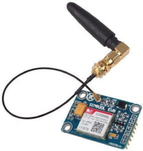
GPS, Radio and SMS modules left to right respectively: